To minimise global warming and its environmental effects, the decarbonisation of electricity production, transport, heating, and industry is a major challenge the world is facing. However, it may not be practical in all parts of the world to deploy zero-carbon technologies immediately, and a portfolio of transitional low-carbon technologies will be needed to reduced greenhouse gas emissions as rapidly as possible. Development of geoenergy technologies, encompassing a range of novel energy technologies and geological sources, is therefore required. For instance, utilisation of deep deposits via gasification and syngas extraction has been identified as one of the technologies that can enable sustainable production of high calorific gaseous products. These technologies require understanding of the geological and engineering controls and risks relating to injection, extraction or interaction with fluids, for their responsible and safe utilisation to achieve a low-carbon future.
Groundwater contamination is considered to the most serious plausible negative environmental impact of subsurface deposit utilisation. Generally, a regulator will require for the potential for contamination to be assessed at some specified location and the assessment methodology should consider a sufficiently long time that peak risks, and the time at which they occur, can be estimated.
Based on its extensive experience in undertaking risk assessments and performance assessments for complex systems based on the application of systems-level mathematical models, Quintessa developed a flexible risk assessment methodology that can be applied at any stage in a geoenergy project, between initial planning and final site abandonment, using an established and internationally recognised structured approach.
Central to the approach was the analysis of scenarios, which represents a “source-pathway-receptor” combination and its evolution. A Reference Scenario and several Alternative Scenarios were developed and analysed using a numerical model developed in Quintessa’s compartment modelling software AMBER. An illustrative application of the methodology to a hypothetical site demonstrated that risks of groundwater contamination should be very low if the site is developed and operated appropriately. The outcomes from applying the numerical model are intended to demonstrate how the methodology and the numerical model can be readily adapted to different sites and different geoenergy technologies seeking to utilise the subsurface in a sustainable manner. The systems models that Quintessa developed can be used to quantify consequences under different conditions, which is invaluable in deciding how to improve management practices.
The work that Quintessa has undertaken contributed to the FLEXIS project, an interdisciplinary research project on flexible integrated energy systems led by Cardiff University, which aimed to make significant advances beyond “state-of-the-art” and evaluate the potential use of deep-lying subsurface deposits for the development of underground coal gasification (UCG) in a safe and environmentally responsible way. The research in this area supported the delivery of the project’s Sustainable Earth Energy (SEREN 2020) theme led by the Geoenvironmental Research Centre.
The risk assessment methodology that Quintessa developed in collaboration with the Geoenvironmental Research Centre and its application to a hypothetical site were recently discussed in a paper published in Journal of Cleaner Production.

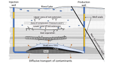
Schematic showing the model components. Blue arrows indicate possible water flows and orange arrows indicate possible contaminant movements.