As part of the EC CO2GeoNet programme of work on the geological storage of carbon dioxide, Quintessa staff, working with colleagues from the British Geological Survey, applied system-level models to the volcanic Latera region in the north of Rome.
CO2GeoNet was a European Union funded Network of Excellence under the sixth Framework Programme. The model used was QPAC-CO2, which is based on Quintessa's general purpose modelling tool Qpac. Information on the site was supplied by staff from the University of Rome which has been involved in studying the area for more than 20 years. This work was funded by the Department of Trade and Industry, and subsequently the Department for Business, Enterprise & Regulatory Reform.
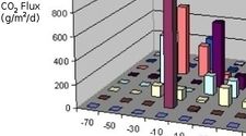
The upper figure illustrates typical calculations for the flux of CO2 to the surface; peak fluxes are in the range of observations at the site.
An ecosystem submodel was used that represents the response of vegetation to the flux of CO2 to the surface. This enables potential impacts on vegetation to be assessed, and an example calculation is shown in the figure on the right. Here each square is 20 m by 20 m, 'normal' growth is indicated by light green colouring, enhanced growth is shown in dark green, and reduced plant growth or plant death is shown in brown.